



:quality(80)/p7i.vogel.de/wcms/54/cb/54cbfdb9d826c9efc90ac358dcf62c6c/ktyvus-624x351v1.jpeg "(Source: Aktyvus Photonics)")
:quality(80)/p7i.vogel.de/wcms/69/11/6911d8eae109755ebaabd914db4b1c20/0133126677v1.jpeg "(Image:AI-generated)")
:quality(80)/p7i.vogel.de/wcms/4c/d5/4cd56185da64b17a838269392691c21e/20260915-171830-1440x810v1.jpeg "For miniature components manufacturer Lee, Managing Director Jürgen Prochno sees new opportunities in Europe arising from future satellite and space programmes. (Photo: Detlev Karg)")
:quality(80)/p7i.vogel.de/wcms/f6/95/f6954fa7c09ba58863a3730f5e384a62/arek-socha-on-pixabay-1707x960v1.jpeg "A new national space strategy brings together UK’s plans for growth, defence, and national security to help reindustrialise the UK. (Source: Arek Socha on Pixabay)")
:quality(80)/p7i.vogel.de/wcms/0a/14/0a1495d9b570ae32a5a7cc748b9a3c60/st-hannover-035-1920x1079v1-999x562v1.jpeg "Fastening technology you can experience first-hand—visitors to Schraubtec in Bochum (Germany) can see it for themselves at the Ruhr Congress on September 30, 2026. (Source: PHOTOVISION-DH GmbH)")
:quality(80)/p7i.vogel.de/wcms/cd/a9/cda92b173afa9d0b455d4f11b281c9ea/0094-to-image--capstone-cdr-1440x810v1.png "(Source: Terran Orbital)")
:quality(80)/p7i.vogel.de/wcms/e0/45/e045bc5414d7263fb308bdd501b5fcc1/0133113962v1.jpeg "The HSWL 354 is the transmission used, for example, in the Leopard 2 main battle tank. Renk manufactures this system and is now preparing to significantly increase its cycle time. As a result, Renk is placing greater emphasis on the military sector as a customer ... (Source: Renk)")
:quality(80)/p7i.vogel.de/wcms/a1/5c/a15c2aeba563d5bc3e11fb879b21eb2c/0132989650v1.jpeg "FSS, the flexible clamping system for varying free-form surfaces, is designed for the aerospace industry and other sectors. (Source: Römheld GmbH Friedrichshütte)")
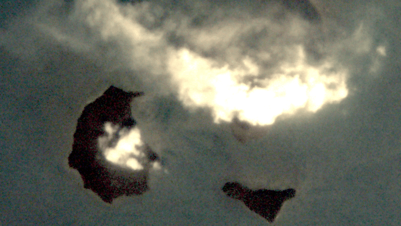
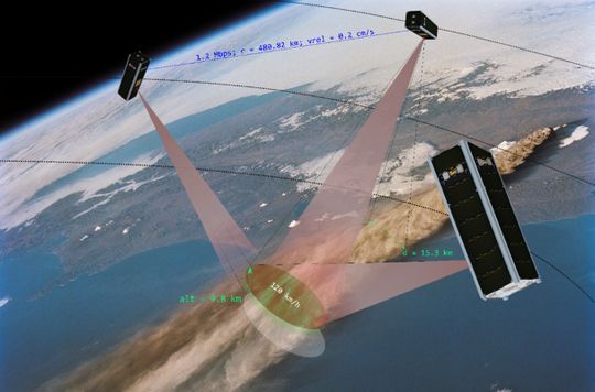
:quality(80)/p7i.vogel.de/wcms/fc/14/fc144df6171fd26da8fe1a0a30c28505/bild-1-tom-bild-der-herausgeschleuderten-aschewolke-anak-krakatau-9-2026-tom-zentrum-f-r-telematik-w-rzburg-802x451v1.png "The TOM satellites happened to be flying over the volcanic island of Anak Krakatau during the eruption and observed the rising volcanic ash cloud from an optimal position as it was ejected to an altitude of up to 15 km (approx. 9.3 miles). (Source: TOM, Center for Telematics Würzburg)")
:quality(80)/p7i.vogel.de/wcms/46/8e/468effa87546a2b036dc88ca40e2843e/129fbcac92ce7da872b13af0281b0799-l-png-1920x1079v1.webp "(Source: Arianespace)")
:quality(80)/p7i.vogel.de/wcms/8f/10/8f10697d4bfbd70edf615cca76eaedfd/pete-linforth-on-pixabay-1920x1080v1.jpeg "(Source: Pete Linforth on Pixabay / AI-generated)")
:quality(80)/p7i.vogel.de/wcms/0f/99/0f99561bf51818af92b2960656405aa5/roland-4d-pippes-on-pixabay-1460x820v1.jpeg "(Source: Roland 4D Pippes on Pixabay)")
:quality(80)/p7i.vogel.de/wcms/9d/8a/9d8addea8cc4e6f7a4793563ca397f2a/ai-im-milit-r-1672x940v1.png "(Source: KI-generiert / Gemini)")
:quality(80)/p7i.vogel.de/wcms/7f/5f/7f5fba2c729ec3aa256bf1a18d74529b/ai-chip-1672x940v1.png "(Source: KI-generiert / Gemini)")
:quality(80)/p7i.vogel.de/wcms/64/1b/641b6474b2a614cde7730c89ef2a3015/2026-09-09-rheinmetall-veroeffentlicht-battlesuite-schnittstellen-e8c18194-1225x690v1.jpeg "Rheinmetall’s Battlesuite provides a modular digital platform for connecting and integrating sensors, hardware and software components. (Source: Rheinmetall AG)")
:quality(80)/p7i.vogel.de/wcms/6f/fe/6ffef325e7f233cc3521943158eb1ebd/0132763535v1.jpeg "Two companies are planning to establish, for the first time in 2027, an optical laser communication link directly between a satellite in low Earth orbit (LEO) and a re-entering spacecraft. (Source: ATMOS Space Cargo)")
:quality(80)/p7i.vogel.de/wcms/8f/f9/8ff91b78b26cb5a2b8a29e39835005b1/2026-09-10-repmus-teaser-images-retouched-dsc01292-1024x683-1024x576v1.jpeg "(Source: Quantum Systems GmbH)")
:quality(80)/p7i.vogel.de/wcms/bf/4a/bf4a237e60d3d4bd1bbdbad918f3c697/airbus-defence-and-space-3-1280x720v1.jpeg "(Source: Airbus Defence and Space)")
:quality(80)/p7i.vogel.de/wcms/e0/d1/e0d112a0d54a4fa9603ec855f7d25b47/t-rex-content-photo-jpg-pc-adaptive-990-medium-988x556v1.jpeg "Swarm of UAVs conducting a fully autonomous collaborative swarm mission. (Source: Lockheed Martin)")
:quality(80)/p7i.vogel.de/wcms/79/fc/79fcaa7ca33e393b11a4740d7d8f3dbe/vilkasss-handshake-9459740-1911x1076v1.jpeg "(Source: Vilius Kukanauskas on Pixabay)")
:quality(80)/p7i.vogel.de/wcms/90/a8/90a849f0023f11d1eb642eb4751a0321/bild2-h-c3-a4nel-ict-20truck-20and-20trailer-20parts-4320x2429v1.jpeg "Product information is visible at all times and retrieval of items
is confirmed by employees directly on the display of the Hänel MP 14 N
controller. (Source: René Marks)")
:quality(80)/p7i.vogel.de/wcms/4e/ca/4ecaa39f247490eded591b652c33aee3/thilmann-hcp-web-20kleiner-20ausschnitt-1442x811v1.jpeg "Entering the defence market can be challenging for start-ups, says HCP Sense CEO Ansgar Thilmann. (Picture: HCP Sense)")
:quality(80)/p7i.vogel.de/wcms/7a/51/7a511b80041d3f1335f3a5aa56fe75da/delivery-7022432-1280-1280x720v1.png "(Source: Mohamed_hassan)")
:quality(80)/p7i.vogel.de/wcms/f9/2f/f92f1ef8c739c34c70d99f7b0997621b/stra007-20--20cover-20image-5472x3076v1.jpeg "(Source: Stratasys)")
:quality(80)/p7i.vogel.de/wcms/ec/a9/eca9062ccbe4b042f8515846340410d8/aerospace-and-defence-stairways-platforms-and-much-morev1.jpeg "Modular constructions enable flexible modification. That applies to larger structures such as stairways and platforms, too. And that means aerospace and defence companies can reconfigure their maintenance platforms fast (itemitem)")
:quality(80)/p7i.vogel.de/wcms/30/2a/302a7b5723ad38fbde812fd3a468ad04/safety-on-stairways-in-industry-key-considerationsv1.jpeg "Stairways and platforms are used widely in maintenance and assembly areas in the aerospace and defence sectors. (Source: item)")
:quality(80)/p7i.vogel.de/wcms/f3/4e/f34ed744bb30817d3432c7ad522e6f30/engine-1v1.jpeg "Engineering with aluminium profiles really can be this easy – the item Engineeringtool and its smart functions help you save valuable time. (Source: item)")
Date: 08.12.2025
Naturally, we always handle your personal data responsibly. Any personal data we receive from you is processed in accordance with applicable data protection legislation. For detailed information please see our privacy policy.
Consent to the use of data for promotional purposes
I hereby consent to Vogel Communications Group GmbH & Co. KG, Max-Planck-Str. 7-9, 97082 Würzburg including any affiliated companies according to §§ 15 et seq. AktG (hereafter: Vogel Communications Group) using my e-mail address to send editorial newsletters. A list of all affiliated companies can be found here
Newsletter content may include all products and services of any companies mentioned above, including for example specialist journals and books, events and fairs as well as event-related products and services, print and digital media offers and services such as additional (editorial) newsletters, raffles, lead campaigns, market research both online and offline, specialist webportals and e-learning offers. In case my personal telephone number has also been collected, it may be used for offers of aforementioned products, for services of the companies mentioned above, and market research purposes.
Additionally, my consent also includes the processing of my email address and telephone number for data matching for marketing purposes with select advertising partners such as LinkedIn, Google, and Meta. For this, Vogel Communications Group may transmit said data in hashed form to the advertising partners who then use said data to determine whether I am also a member of the mentioned advertising partner portals. Vogel Communications Group uses this feature for the purposes of re-targeting (up-selling, cross-selling, and customer loyalty), generating so-called look-alike audiences for acquisition of new customers, and as basis for exclusion for on-going advertising campaigns. Further information can be found in section “data matching for marketing purposes”.
In case I access protected data on Internet portals of Vogel Communications Group including any affiliated companies according to §§ 15 et seq. AktG, I need to provide further data in order to register for the access to such content. In return for this free access to editorial content, my data may be used in accordance with this consent for the purposes stated here. This does not apply to data matching for marketing purposes.
Right of revocation
I understand that I can revoke my consent at will. My revocation does not change the lawfulness of data processing that was conducted based on my consent leading up to my revocation. One option to declare my revocation is to use the contact form found at https://contact.vogel.de. In case I no longer wish to receive certain newsletters, I have subscribed to, I can also click on the unsubscribe link included at the end of a newsletter. Further information regarding my right of revocation and the implementation of it as well as the consequences of my revocation can be found in the data protection declaration, section editorial newsletter.
:quality(80)/p7i.vogel.de/wcms/29/57/2957386c9f15d8ee16b07f95523834d5/cuby-5-deployment-20-28-c2-a9-20oliver-20ruf-20s4-20gmbh-20-20w-c3-bcrzburg-20-20-20credits-20spacex-20videostream-29-1920x1079v1.png "At the top left, CuBy-5 is being deployed from the container attached to the rocket. (Source: Oliver Ruf S4 GmbH Würzburg, credits: SpaceX videostream)")
:quality(80)/p7i.vogel.de/wcms/c6/dc/c6dccef07c2e281718e7a41a49ebf9df/esa-20solarflare-1563x879v1.jpeg "Extreme-ultraviolet imagery from 11 November 2025 shows the solar eruption sequence that preceded the geomagnetic storm, captured by ESA and partner observatories. (Source: European Space Agency)")